Просмотр новости
Найдите то, что Вас интересует
 Спутники
 РН
РН SpaceX
 Роскосмос
 NASA
NASA
СпутникиРНSpaceXРоскосмосNASAPolo churns off Mexico with up to eight inches of rain and 46-foot seas, while another strengthening tropical system threatens eastern Hawaii with dangerous surf and rainfall of 10 to 30-plus inches.
[Haz clic aquí para leer esta nota en español]
Hurricane Polo continues to rage in the northeast Pacific Ocean, fluctuating between Categories 4 and 5 since its extreme rapid intensification from Monday into Tuesday, September 21-22. Update (11 p.m. EDT Wednesday): Polo has once again reached Cat 5 strength, with top sustained winds of 160 mph. Tropical storm warnings are in effect from Tecpan de Galeana to Manzanillo, Mexico, including the entire coastline of Michoacán state. A tropical storm watch is in effect westward to Playa Pérula along the coast of the western Mexican state of Jalisco.
Polo reached Category 5 intensity with astonishing speed, leaping from tropical storm strength early Monday to maximum sustained winds of 180 mph (285 km/h) and a minimum central pressure of 892 mb (hPa) on Tuesday. According to Phil Klotzbach, that 892-mb reading is the second-lowest on record in the eastern Pacific, just behind Hurricane Patricia in 2015, whose 872-mb minimum was a record for the entire Western Hemisphere.
 Figure 1. Official forecast track for Hurricane Polo as of 9 a.m. CST (11 a.m. EDT) Wednesday, September 23, 2026. Polo is forecast to parallel Mexico’s Pacific coast and hold its major category status through the weekend, approaching Baja California by Monday. (Image credit: National Hurricane Center)
Polo has maintained a very compact core, at times displaying a double-eyewall structure as it fluctuates in intensity while remaining a strong hurricane. Polo’s compact initial size helped it to intensify so rapidly, but Polo is now starting to expand as is common with maturing hurricanes. As of 11 a.m. EDT Wednesday, Polo’s top sustained winds were at 150 mph, making it a strong Cat 4 storm, and its estimated central pressure had risen to 922 mb. Polo was centered about 165 miles (270 km) south of Zihuatanejo, Mexico. Hurricane-force winds extended up to 40 miles (65 km) from the center, and tropical-storm-force winds extended up to 105 miles (165 km) from the center.
Hurricane Polo has been a very slow-moving storm since its extreme rapid intensification. The slow movement is linked to the storm making an unusually sharp turn toward the northwest. Before doing so, it had been traveling east-southeast on Monday, and by Tuesday the storm finally started making a turn toward the north, barely moving at 2 mph. On Wednesday morning, the storm was basically stationary, and it is expected to remain within the same general area through much of Wednesday. By the afternoon, the storm should begin moving west-northwest and gradually pick up some speed.
The snail’s-pace movement makes it especially impressive that Polo was able to intensify so rapidly and maintain most of its strength into Wednesday, given that slow-moving hurricanes can more easily churn up cooler water. In this case, exceptionally warm water extends to unusual depths – in large part due to the record-setting El Niño that continues to intensify in the eastern tropical Pacific, on top of long-term human-caused warming. Data from Argo floating buoys showed that the water more than 60 meters (200 feet) below the ocean surface where Polo intensified was warmer than 30 degrees Celsius (86 degrees Fahrenheit), more than ample to sustain an intense hurricane.
Short-range forecast for PoloPolo will be making an initial pass near Mexico’s west-central Pacific coast on Wednesday and Thursday, followed by a potential landfall on the Baja California peninsula around Monday.
The silver lining with Polo’s first pass is that the strongest winds, as well as the most intense rainfall, are expected to remain offshore and not directly impact the west-central coast of Mexico. But keep in mind that coastal areas of Guerrero, Michoacán, Colima, and Jalisco could experience rainbands capable of producing very strong wind gusts and torrential rainfall. This area of Mexico has steep terrain, which could increase the risk of landslides and mudslides due to torrential rainfall coming in from the Pacific. Rainbands have already begun affecting portions of the region at times and will continue to impact the west-central coast of Mexico through at least Thursday morning. By that point, the storm will begin making a turn more toward the west, moving away from the west-central coast of Mexico.

Polo’s greatest impact on the west-central coast of Mexico will likely come from heavy rainfall. Rainbands will remain persistent through at least Thursday as the system stays roughly parallel to the coast. By Friday, as the system moves away, the rainbands could still impact portions of Colima and Jalisco but should become more sparse across Michoacán and Guerrero. General rainfall totals along the coast could range between two and four inches. Some locations in Guerrero, where the storm has remained nearly stationary and parallel to the coast for a longer period, could end up receiving four to six inches (100 to 150 mm). Isolated locations could receive up to eight inches of rain. Mudslides and life-threatening flooding are possible, especially across areas of steep terrain.
Surf conditions with Polo have been extremely high. Near the center of Polo, the National Hurricane Center’s marine analysis estimated wave heights of around 46 feet, or 14 meters, on Wednesday morning.
Long-range outlook for PoloOver the weekend, Polo will begin a gradual recurvature, turning toward the northwest on Saturday and likely taking a more northerly track by early next week. By this point, Polo will be moving over slightly cooler waters and into a more hostile vertical wind-shear environment. These conditions will begin to disrupt the hurricane’s structure and force it to steadily weaken. But it’s quite possible Polo will still be a significant hurricane as it approaches Baja California, and its circulation will have expanded by that point, so coastal residents will need to monitor the forecast closely.
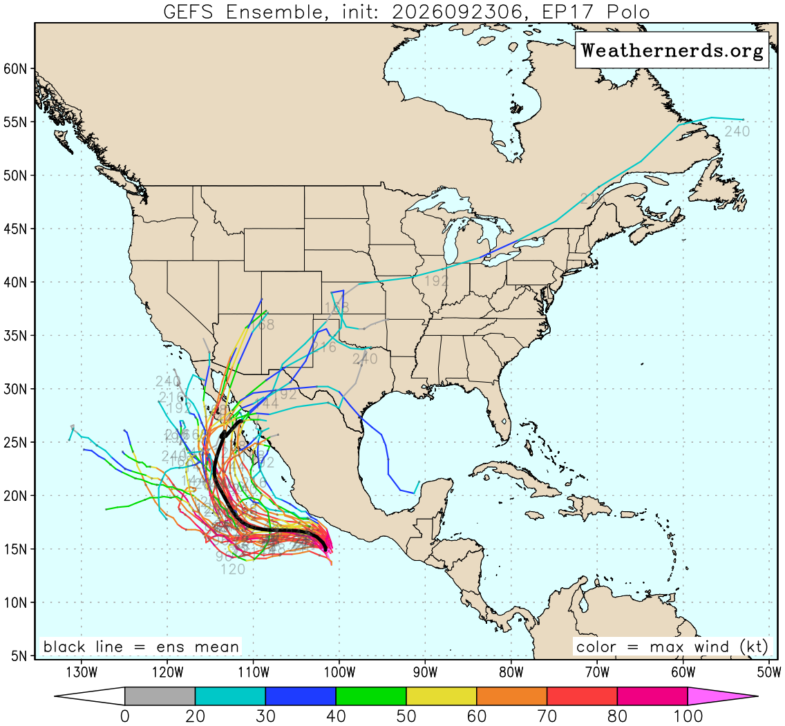
Most of the long-range GFS ensemble members on Wednesday morning suggested that Polo will make landfall on the coast of Baja California early next week, though a minority of GFS tracks angle back offshore before any landfall. The Google DeepMind ensemble was nearly unanimous on a Baja California landfall, with the intensity depending in part on how quickly Polo is moving at that point. By later next week, Polo’s remnants could juice the atmosphere and help fuel localized heavy rains into northwest Mexico and perhaps parts of the southwest and south-central United States.
As Polo tracks toward Baja California, it will likely pass just west of the small island of Socorro. The island has a permanent population of roughly 250 people, consisting mainly of Mexican Navy personnel, staff, and their families.
This year’s Category 5 storms to datePolo is the planet’s seventh Category 5 tropical cyclone of 2026. The others thus far:
The 1990-2025 average yearly number of Category 5 storms globally was 5.3; there were five in 2025 (Hurricanes Melissa, Erin, and Humberto in the Atlantic; Typhoon Ragasa in the Northwest Pacific; and Cyclone Errol in the South Indian Ocean).
 Figure 3. The number of Cat 5 tropical cyclones globally from 1982-2026, according to ratings from the National Hurricane Center and Joint Typhoon Warning Center.
The number of Cat 5s has increased globally since accurate global satellite data became available in 1982 (this increase is statistically significant at the 99.5% level). Numerous studies over the past 20 years have found that hurricane-strength storms are not becoming more numerous globally, but the fraction of such storms that reach Category 4 or 5 strength is growing and expected to keep growing, so the world is seeing more of these intense tropical cyclones, which tend to be the most deadly and destructive ones.
Also in the Eastern Pacific: Odalys and moreHurricane Odalys intensified early Wednesday morning and is now a hurricane, with maximum sustained winds of 75 mph, or 120 km/h. This system is over the open eastern Pacific and is expected to remain well away from land. There are no coastal watches or warnings in effect. Odalys is expected to continue meandering across the open waters, generally taking an east-northeast track before gradually dissipating over the weekend while remaining well away from the Baja California Peninsula.
NOAA/NHC has also highlighted an area near where Polo is currently located that has an 80% chance of tropical development during the next seven days. Late this week, as Polo accelerates northwestward, another low-pressure system is expected to form just south of the Gulf of Tehuantepec. From there, a tropical depression is likely to form over the weekend as the system moves slowly toward the west-northwest, also remaining roughly parallel to the southern and southwestern coast of Mexico. We will continue to monitor this system closely, as additional rainfall could affect some of the same areas impacted by Hurricane Polo next week. The next name on the Eastern Pacific list is Rachel.
 Figure 4. Official forecast track for TD 15-E issued at 5 a.m. HST (11 a.m. EDT) on Wednesday, Sept. 23, 2026. TD 15-E will move slowly west in the short term, then shift to a northward track while intensifying over the next several days. (Image credit: NHC)Massive rains, catastrophic flooding possible in eastern Hawaii this weekend
Update (11 p.m. EDT Wednesday): A new tropical storm in the Central Pacific poses a serious flooding threat to eastern Hawaii, including Maui and the Big Island, by this weekend. Tropical Depression 15-E became Tropical Storm Nolo on Wednesday afternoon. As of late Wednesday, NHC was predicting that Nolo could nudge as close as 100 miles to the Big Island as a major hurricane. A hurricane watch was in effect for the entire island (Hawaii County).
The setup for Nolo is especially concerning in its rarity. No major hurricane on record has tracked this close to the Big Island, and of the handful of majors that have passed within 250 miles, all were moving on straightforward west-to-east tracks. Nolo will be approaching from the south, which could yield a much more prolonged period of intense onshore flow and torrential rainbands. Making matters even worse, the circulation around the north side of this system already has a broad shield of unusually rich atmospheric moisture, with precipitable water amounts exceeding 2.75 in. (70 mm).
 Figure 5. All major hurricanes on record (i.e., Category 3 or stronger) that have passed within a radius of 250 miles of Kau, on the southeast coast of Hawaii’s Big Island. All of these passed on general east-to-west tracks, whereas Nolo is expected to slowly approach from the south. (Image credit: NOAA Hurricane History)
 Figure 6. Rainfall forecast for Tropical Storm Nolo issued at 5 p.m. HST (11 p.m. EDT) Wednesday, September 23, 2026. Powerful winds and constant rainbands circulating around the system and pushing northwest into the higher terrain of eastern Hawaii are predicted to bring massive rain totals to southeast parts of the Big Island and Maui. (Image credit: NOAA/NWS/WPC via NHC)
Widespread rainfall totals of 20 to 30 inches (500-750 mm) are predicted across the southeast half of the Big Island, and 12-16 inches (300-400 mm) over southeastern Maui. Isolated totals could reach 35 inches on the Big Island and 20 inches on Maui. Life-threatening flash flooding and mudslides are possible, especially in areas of higher elevation. Large swells are also expected as the storm continues to strengthen. Wave heights are expected to increase along south- and east-facing shores, producing life-threatening surf and rip currents.
How close this system gets to the Big Island before making its left turn west depends on the evolution of an upper low that will be moving southwestward on the other side of Hawaii over the next few days. The timing and motion of this upper low’s evolution is tough to nail down, and so there’s higher uncertainty than usual in the track forecast for Nolo. But there’s stronger agreement on the northward track prior to the turn, and this unusual motion will help ensure a significant and possibly destructive rainfall event for Hawaii.
— Collin Gross (@CollinGrossWx) September 24, 2026#Nolo poses a significant threat to Hawaii, making its closest pass on Saturday as a major hurricane.
Even if the core misses to the southwest, significant rainfall is likely, totaling 15-30+ inches on the Big Island & Maui. Life-threatening flooding/mudslides possible. pic.twitter.com/Leih1F3Rvu
The remnants of what was once Fay continue to meander about 800 miles south of the Azores. This area is moving westward over the next few days, and although it has a low chance of tropical development, vertical wind shear is expected to increase. This should eventually eliminate its chances of redeveloping into a tropical system. Update (11 p.m. EDT Wednesday): Tropical Storm Fay has re-emerged from the remnants of its first incarnation, with top sustained winds of 40 mph. Fay could persist as a weak tropical storm for a couple of days as it drifts westward, with no impacts to land expected.
Coming off the coast of Africa, an area of low pressure located about 600 miles southeast of the Cabo Verde Islands could become the next short-lived tropical depression on Thursday. The Cabo Verde Islands could experience gusty winds and heavy rainfall late this week before the system enters an area of strong upper-level winds, which should bring an end to its tropical development.
Nor’easter to bring coastal flooding to the mid-Atlantic and NortheastThe season’s first extratropical coastal storm (a “nor’easter”) was developing on Wednesday off the coast of North Carolina and will move slowly northeastward toward New England over the next few days, bringing heavy rains and flooding. The Wednesday forecast from NOAA calls for major coastal flooding in northern North Carolina and in Virginia along Chesapeake Bay on Thursday, with moderate flooding along portions of the coast of Maryland, New Jersey, and Delaware. Coastal flooding at high tide is expected to continue on Friday and Saturday for many of these locations. Moderate coastal flooding is likely to begin on Friday and last into Saturday for coastal New York, Connecticut, Rhode Island, and Massachusetts.
Nor’easters are uncommon this time of year, with only about 1% of all such storms occurring in September.
— Ben Noll (@BenNollWeather) September 23, 2026Nor’easters are not at all common this time of the year.
Only 1 percent of them have historically occurred during September.
Around 90 percent of them occur from November to April. pic.twitter.com/HNziwOYf2K

Republish our articles for free, online or in print, under a Creative Commons license.